







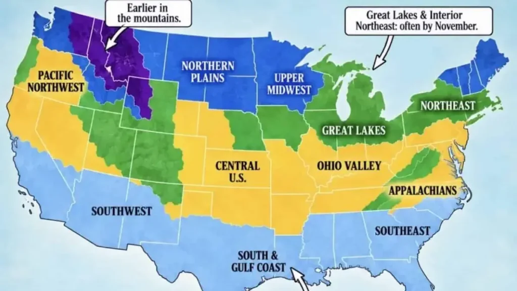
As September unfolds and a new winter season inches closer, millions of Americans are turning their attention to a familiar seasonal question: when will the first snow arrive? The Farmers’ Almanac First Snowfall Map 2026 has become a key resource for those seeking answers, offering a broad, climatology-based guide to when the season’s first flakes typically appear across the United States.





The map, which draws on decades of weather records, is not a storm-specific forecast. Instead, it provides a regional timeline based on historical patterns—showing where winter arrives earliest and which areas may wait until deep into December or beyond. Understanding this distinction is essential for anyone using the map to plan travel, prepare for winter weather, or simply satisfy curiosity about the season ahead.
This explainer breaks down what the Farmers’ Almanac First Snowfall Map 2026 shows, how it relates to the broader 2026–2027 winter outlook, and why local forecasts remain the most reliable tool for pinpointing when snow will actually fall in your area.
Farmers’ Almanac First Snowfall Map 2026: What It Shows
The Farmers’ Almanac First Snowfall Map 2026 is a visual guide that illustrates when the first measurable snowfall—defined as at least 0.1 inches of accumulation—typically occurs across different regions of the United States. The map uses color-coded bands to represent timing windows, ranging from August–September in the highest mountain elevations to December–January in the Deep South and Gulf Coast areas where snow is rare.
Crucially, this map is a climatological reference rather than a prediction for any specific storm or season. It reflects median dates derived from historical weather station data, giving readers a sense of what is typical rather than what will definitely happen in 2026.
The color-coded system generally breaks down as follows:
| Map Color | Typical First Snowfall | Areas Most Likely |
|---|---|---|
| Purple | August–September | Highest elevations and far northern mountain areas |
| Blue | October | Northern Rockies, northern Plains, Upper Midwest, parts of northern New England |
| Green | November | Great Lakes, central Rockies, interior Northeast, higher Appalachians |
| Yellow | Late November–December | Central Plains, Ohio Valley, Mid-Atlantic interior, lower-elevation Northwest |
| Light Blue | December–January or rare | Deep South, Gulf Coast, lower Southeast, desert Southwest lowlands and Florida |
This structure helps readers quickly identify their region and understand the general timeframe when snow becomes climatologically possible. However, the map’s broad strokes should not be mistaken for precise dates. Elevation, latitude, proximity to bodies of water, and year-to-year weather patterns can shift the first snowfall significantly earlier or later than the median.
For example, Denver’s average first measurable snowfall occurs around October 18, but the city has recorded snow as early as September and as late as December. Similarly, Dodge City, Kansas, has seen its first snow anywhere from mid-September to early January over a 65-year record—a swing of nearly three and a half months.
When Will the First Snow Arrive in the U.S.?
The arrival of the first snow in the United States follows a predictable geographic pattern shaped primarily by latitude and elevation. Northern and mountainous regions generally see snow earliest, while southern and coastal areas may wait until mid-winter—or not see snow at all in a given year.
The Earliest Snow: High Elevations and Far North
The highest peaks of the Rocky Mountains and other northern mountain ranges can receive snow as early as August or September. These early-season snowfalls often melt quickly as warmer weather returns, but they signal the beginning of the seasonal transition. Alaska’s interior and northern Canada also fall into this earliest category, with some locations seeing their first snow before mid-September.
October: The Northern Snow Belt Awakens
By October, the first measurable snow becomes increasingly common across Montana, Wyoming, Colorado, North Dakota, northern Minnesota, and the higher elevations of Utah and Idaho. Northern New England also begins to see its first flakes during this month, particularly in the mountains of Maine, New Hampshire, and Vermont.
The northern Great Lakes region—including northern Michigan, Wisconsin, and Minnesota—also typically experiences its first accumulating snow in October.
November: Snow Spreads Across the Northern Half
November is arguably the most significant month for first snowfall across the United States. As daylight decreases and cold Canadian air masses push southward, the odds of snow rise dramatically across the northern half of the country.
Typical November first-snow areas include:
- The Upper Midwest
- The Great Lakes region
- The northern and central Plains
- The interior Northeast
- The central Rockies
- The higher Appalachians
Cities like Minneapolis average their first measurable snowfall around November 4, while Buffalo typically sees its first accumulating snow around November 8. The Great Lakes play a particularly important role during this period, as relatively warm lake water can fuel intense lake-effect snow bands when cold air moves across the region.
Late November–December: Snow Reaches Farther South
By late November and December, the first accumulating snow becomes increasingly possible across Kansas, Missouri, the Ohio Valley, Pennsylvania, New Jersey, Maryland, Virginia, and the lower elevations of the Pacific Northwest.
The Interstate 95 corridor from New York City to Virginia typically waits until December for its first measurable snowfall. Parts of southeast Kansas, southern Missouri, and the Lower Ohio Valley also typically see their first accumulating flakes in December.
The South: Snow Is Rare and Often Late
For much of the southern United States, accumulating snow is not an annual certainty. When it does occur, January and February are the most favorable months for at least a coating of snow from the Carolinas to northern Texas.
The Texas Panhandle and the highest elevations of the southern Appalachians are exceptions, typically seeing their first snow in November or December. Valley locations of the southern Appalachians, parts of northern and Middle Tennessee, northern Arkansas, and central and eastern Oklahoma may see their first dusting in December—if at all.
First Snowfall Timing by Region
The following table provides a regional overview of typical first snowfall timing. These are general patterns based on historical data, not predictions for the 2026–2027 season specifically.
| Region | Typical First Snow Timing | What Readers Should Know |
|---|---|---|
| Northern Rockies & High Plains | September–October | Elevation is the dominant factor; mountain peaks may see snow in September while valleys wait until October or November |
| Northern Plains (Dakotas, Montana) | October–November | Early cold fronts from Canada can bring snow before Halloween in some years |
| Upper Midwest (Minnesota, Wisconsin, Michigan) | October–November | Northern areas see snow earlier; lake-effect snow can begin in November |
| Great Lakes Region | November | Lake-effect snow bands can produce intense localized snowfall |
| Northeast (Interior) | November | Higher elevations see snow earlier than coastal areas |
| Northeast (Coastal/I-95 Corridor) | December | New York City to Washington, D.C. typically waits until December |
| Central Plains (Kansas, Nebraska) | November–December | Timing varies widely; early snow is possible but not guaranteed |
| Ohio Valley | November–December | Southern portions may not see snow until December |
| Pacific Northwest (Low Elevations) | December or later | Seattle and Portland rarely see snow before late December |
| Southern States | December–January or rare | Much of the South does not see accumulating snow every year |
| Gulf Coast & Florida | Rare | Snow is exceptionally unusual in these regions |
When Will It Snow in Your State?
While the Farmers’ Almanac First Snowfall Map 2026 provides regional guidance, many readers want to know what to expect in their specific state. The following summaries draw on climatological data and should be understood as general patterns rather than precise forecasts.
Western States
Alaska: Interior Alaska and northern regions can see snow as early as September, with some areas experiencing snow in August. Coastal areas typically wait until October or November.
Colorado: The high Rockies can see snow in September, while Denver averages its first measurable snowfall around October 18. Lower elevations of the Eastern Plains may not see snow until November or December.
Idaho: Mountain areas typically see first snow in October, while lower elevations may wait until November. Northern Idaho often sees snow earlier than southern regions.
Montana: One of the earliest states for snowfall, with mountain areas seeing snow in September and lower elevations typically receiving their first accumulations in October.
Wyoming: Similar to Montana, high elevations see September snow, while lower basins and plains typically wait until October.
Utah: The Wasatch Range and higher elevations typically see first snow in October, while Salt Lake City and other valley locations may wait until November.
Washington and Oregon: The Cascade Mountains can see early-season snow in October or November, but lowland areas—including Seattle and Portland—rarely see accumulating snow before late December.
Midwest States
Minnesota: Northern Minnesota typically sees its first snow in October, while the Twin Cities averages its first measurable snowfall around November 4.
Wisconsin: Northern areas may see October snow, while southern Wisconsin typically waits until November.
Michigan: The Upper Peninsula and northern Lower Michigan often see October snow, while southern areas typically wait until November. Lake-effect snow can bring significant early-season accumulations.
Illinois: Northern Illinois may see November snow, while central and southern portions of the state typically wait until late November or December.
Indiana and Ohio: These states typically see their first measurable snow in November or December, with northern areas receiving snow earlier than southern regions.
Iowa: Northern Iowa may see November snow, while southern portions typically wait until late November or December.
Missouri: Northern Missouri may see snow in November or December, while southern Missouri often waits until December or later.
Nebraska and Kansas: Western portions of these states typically see first snow in November, while eastern areas may wait until December.
Northeastern States
New York: Upstate and western New York typically see first snow in November, with lake-effect regions experiencing earlier and heavier snowfall. New York City typically waits until December.
Pennsylvania: Northern and western Pennsylvania may see November snow, while southeastern areas typically wait until December.
Massachusetts: Western Massachusetts may see November snow, while Boston and coastal areas typically wait until December.
Maine, Vermont, and New Hampshire: These northern New England states often see their first snow in October or November, with mountain areas receiving snow earliest.
Southern States
Virginia and West Virginia: Western Virginia and the mountains of West Virginia may see snow in November or December, while eastern and coastal areas typically wait until December or January.
Tennessee: Higher elevations of eastern Tennessee may see December snow, while western portions of the state often wait until January—if snow occurs at all.
North Carolina: Mountain areas may see December snow, while the Piedmont and coastal regions typically wait until January or later.
Georgia: Accumulating snow is uncommon in most of Georgia. When it occurs, January and February are the most likely months.
Will the First Snow Come Early or Late in 2026?
This is one of the most common questions readers ask when viewing the Farmers’ Almanac First Snowfall Map 2026. The honest answer requires distinguishing between several different types of forecasts:
Typical first snowfall timing: The map shows median dates based on decades of historical records. These represent what is most common, not what will happen in any given year.
Seasonal winter outlook: The Farmers’ Almanac’s 2026–2027 winter forecast provides broad expectations for temperature and precipitation patterns across regions. This is different from a first-snow prediction.
Short-range weather forecasts: These are the most reliable tools for predicting actual snow events. The National Weather Service and other meteorological organizations provide forecasts that become increasingly accurate as an event approaches.
Exact storm prediction: No seasonal almanac can predict the exact date of a specific snowstorm weeks or months in advance. As meteorologists frequently note, weather systems are chaotic and cannot be fully modeled that far ahead.
For the 2026–2027 season, NOAA’s Climate Prediction Center has indicated a strengthening El Niño pattern, with more than 90% confidence in a “very strong” El Niño during the fall and winter. El Niño winters typically bring wetter conditions to the southern United States and drier patterns to the Pacific Northwest and Northern Rockies.
This could mean that some southern regions see more precipitation than usual, potentially increasing the odds of winter weather if cold air is present. Meanwhile, the Pacific Northwest and Northern Rockies might see a slower start to their snow season.
However, these are probabilistic patterns, not guarantees. The actual timing of the first snow in any location will depend on the specific weather patterns that develop during the season.
Farmers’ Almanac Winter Forecast 2026–2027
The first snowfall map is part of the Farmers’ Almanac’s broader winter outlook for 2026–2027, which was released in August 2026. The publication describes the upcoming winter as one “defined by contrasts,” with different regions experiencing very different conditions.
Key Themes from the Farmers’ Almanac Winter Forecast
Southern Storm Track: The Almanac predicts an active and wet southern storm track, bringing above-normal precipitation from Southern California through the desert Southwest, Texas, the Gulf Coast, and the Southeast. If temperatures drop sufficiently, this could mean sleet, freezing rain, or heavy wet snow—particularly in the southern Rockies.
Northern Cold and Snow: The northern Plains, Upper Midwest, and Great Lakes regions are expected to see quick bursts of snow and cold, with fast-moving storm systems bringing sudden temperature drops and brief but intense snow episodes.
Northeast Complexity: The Northeast is expected to experience a particularly unpredictable mix of precipitation. Coastal areas may see more rain or a mix of freezing rain and ice, while inland regions—including Pennsylvania, western New York, and parts of New England—could face heavy, wet snow, especially during January and February.
Pacific Northwest: The Almanac suggests the Pacific Northwest may experience a somewhat less dependable snow season, with drier conditions potentially limiting snowfall in lower elevations.
About 150 million people across 29 states from Maine to Montana are expected to experience periods of snow and sub-zero temperatures from December 2026 through March 2027, according to the Almanac’s forecast.
How Accurate Is the Farmers’ Almanac First Snowfall Map?
The accuracy of the Farmers’ Almanac’s forecasts has been a subject of debate for years. The publication claims an accuracy rate of 80–85% for its long-range predictions, but independent analyses have questioned these figures.
Research cited by meteorologists suggests that only about half of the forecasts produced by the Farmers’ Almanac were correct—essentially a coin toss. The publication’s formula, which dates back to 1818, is based on factors including lunar cycles, solar activity, and historical weather patterns.
Modern meteorologists note several limitations of almanac-style forecasting:
- Chaotic weather systems: The atmosphere is a chaotic system that cannot be accurately modeled weeks or months in advance.
- Vague predictions: Almanac forecasts often use general language that can be interpreted in multiple ways, making verification difficult.
- Lack of transparency: The proprietary formulas used by almanacs are not subject to peer review or scientific scrutiny.
The National Weather Service typically does not release its winter outlook until mid-October, and even those outlooks are probabilistic rather than deterministic. As one meteorologist noted, “It’s just not possible” to predict specific weather events like major winter storms far in advance.
This does not mean the Farmers’ Almanac First Snowfall Map 2026 is without value. As a climatological reference based on historical data, it provides useful context for understanding when snow typically arrives in different regions. However, readers should treat it as a general guide rather than a precise forecast.
What Does the First Snowfall Map Mean for Travelers and Residents?
Understanding typical first snowfall timing can help travelers and residents prepare for winter weather, but it should not replace local forecasts when making decisions.
Practical Tips for Winter Preparation
Monitor local forecasts: The most reliable information about upcoming snow comes from the National Weather Service and local meteorological sources. Check forecasts regularly as winter approaches.
Prepare vehicles: If you live in or travel through areas that see early snow, ensure your vehicle is ready for winter conditions. This includes checking tires, wipers, and fluid levels, and keeping an emergency kit with blankets, food, and water.
Plan travel flexibly: If you are traveling to or through mountainous regions in October or November, be aware that snow is possible—even if it is not in the immediate forecast. Mountain passes can become hazardous quickly.
Know the difference between snow types: The first flakes of the season often melt on contact and cause few problems. Measurable snow (0.1 inches or more) can create slippery conditions, while significant snowfall (1 inch or more) may require shoveling and affect travel.
Be cautious about early-season snow: Early-season snowstorms can catch people off guard because winter preparations may not yet be complete. Even a modest snowfall can cause problems if roads have not been treated and drivers are not accustomed to winter conditions.
Frequently Asked Questions
When will the first snow arrive in 2026?
The first snow typically arrives in September or October in the highest mountain elevations and northernmost regions, while most of the northern United States sees its first measurable snow in October or November. Southern states may wait until December, January, or not see snow at all. The Farmers’ Almanac First Snowfall Map 2026 provides regional timing based on historical patterns, not specific 2026 predictions.
What does the Farmers’ Almanac First Snowfall Map show?
The map shows the typical timing of the first measurable snowfall (at least 0.1 inches) across the United States using color-coded bands. It is based on historical weather data and represents median dates, not predictions for a specific season. The map helps readers understand when snow is climatologically likely in their region.
Which U.S. states get their first snow earliest?
The earliest snow typically occurs in Alaska’s interior, the highest elevations of the Rocky Mountains in Montana, Wyoming, and Colorado, and far northern mountain areas. These regions may see their first snow in August or September. Northern Plains states like North Dakota and Montana also see early snow, typically in October.
When does the first snow usually arrive in the Northeast?
In the Northeast, the first snow typically arrives in October in the mountains of northern New England and the Adirondacks. Most of the interior Northeast sees its first snow in November, while the Interstate 95 corridor from New York City to Virginia typically waits until December.
Is the Farmers’ Almanac first snowfall map accurate?
The map is based on historical climatological data, so it accurately represents typical first snowfall timing. However, it is not a forecast for any specific year. The Farmers’ Almanac’s longer-range weather predictions have been questioned by meteorologists, with research suggesting about 50% accuracy. The first snowfall map should be used as a general guide, not a precise prediction.
Can the map predict the exact first snow date?
No. The Farmers’ Almanac First Snowfall Map 2026 shows typical timing based on historical averages, not exact dates for the upcoming season. The actual first snow in any location depends on specific weather patterns that cannot be predicted weeks or months in advance. For precise snow predictions, consult short-range local forecasts.
When does winter begin in the United States?
Astronomical winter begins on the winter solstice, which falls on December 21, 2026, at 3:50 PM EST. However, meteorological winter begins on December 1 and encompasses the months of December, January, and February. The first snowfall often occurs well before the official start of winter in northern regions.
Where can I check the latest local snow forecast?
The most reliable sources for local snow forecasts are the National Weather Service (weather.gov), local television and radio meteorologists, and reputable weather apps and websites. These sources provide short-range forecasts that are updated frequently and account for current weather patterns, unlike seasonal almanacs.